

The Colorado River: Designing Basin “2.0”
The Colorado River Basin was transformed into one of the most ambitious hydraulic engineering systems ever built, with a vast network of massive reservoirs, dams, canals, aqueducts, and pumping systems. The system allowed major cities to grow, vast agricultural regions to be irrigated, and industry to expand across some of the driest parts of North America. Today, the Colorado River Basin supplies water to roughly 40 million people and irrigates approximately 5.5 million acres of farmland.
The system worked well for decades. Reservoirs, groundwater systems, engineering, and periodic wet years buffered the basin against hydrologic imbalance. Lake Mead, Lake Powell, and basin aquifers functioned as giant multi-year “water batteries”, charging and discharging over time.
But the Colorado River Basin now operates under very different conditions than the system was originally designed for. The assumptions that shaped the twentieth-century Colorado River Basin no longer match the basin’s hydrology, variability, and current demands. The operating rules that have governed the basin since 2007 expire at the end of 2026 and present a rare opportunity to redesign the system.
Foundational Flaws
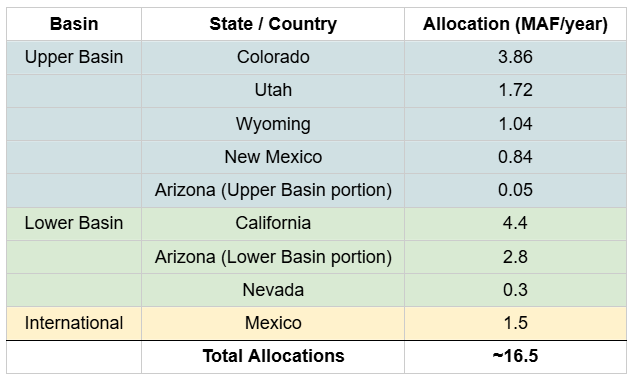
The 1922 Colorado River Compact divided the basin into Upper and Lower Basins and allocated 7.5 million acre-feet (MAF) of water annually to each. Additional legislation, interstate agreements, court rulings, and treaties (including the 1944 treaty allocating 1.5 MAF annually to Mexico) expanded the range of policies into the “Law of the River,” the legal framework that still governs the basin today.
The planners who designed the twentieth-century Colorado River system believed the river carried roughly 16.4 MAF annually on average, based largely on flow measurements during an unusually wet period in the historical record. Modern measurements, paleohydrology, and observed flows since 2000 show that the river’s long-term average flow is materially lower and more variable than assumed.
The 1922 negotiations also had a second problem. Thirty federally recognized tribes hold rights to Colorado River water, many of them senior to state allocations under the Winters Doctrine (federally reserved water rights). But tribes were not included in basin negotiations, and a significant share of tribal rights remain unquantified or undelivered today.
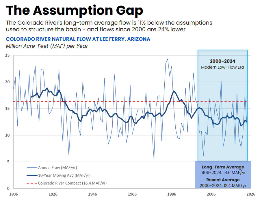
Caption: The Colorado River Compact was negotiated during an unusually wet period in the historical record. Modern measurements and paleohydrology show that the river’s long-term average flow has been lower than the assumptions used to structure the basin. Source: https://www.usbr.gov/lc/region/g4000/NaturalFlow/provisional.html
A River Engineered at Continental Scale
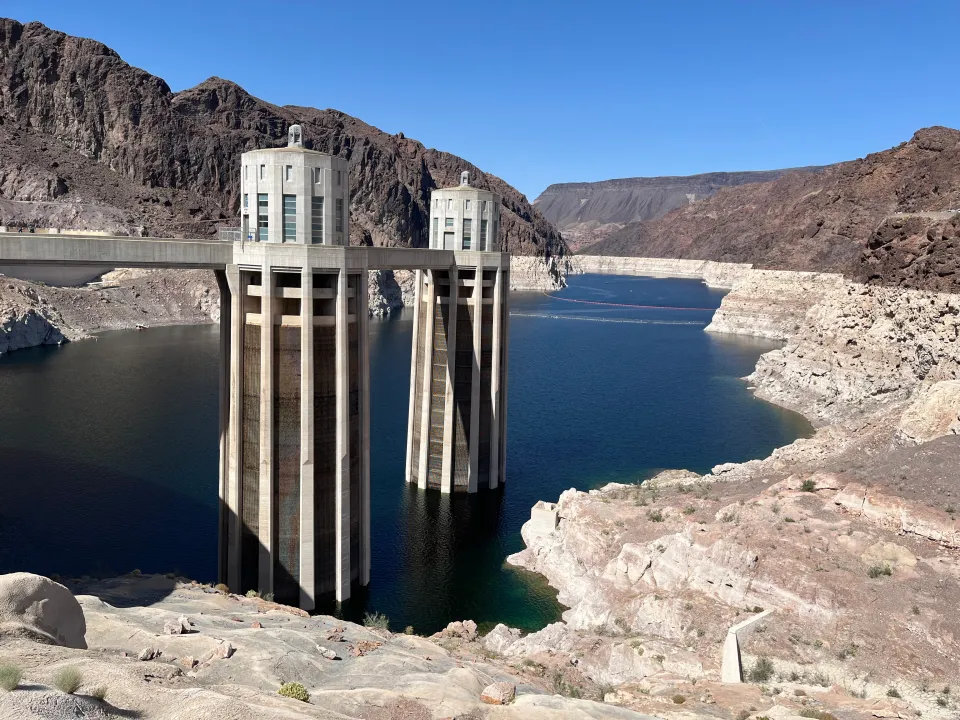
The Colorado River system operates at an extraordinary scale. Lake Powell (in the Upper Basin, formed by the Glen Canyon Dam in northern AZ) and Lake Mead (in the Lower Basin, formed by the Hoover Dam on the AZ/NV border) together can store roughly 50 MAF of water - equivalent to three to four years of Colorado River flow. These reservoirs provided enormous operational flexibility that stabilized the basin for decades despite increasing hydrologic stress. For context, 1 MAF of water is about the annual use of 8 million people in the West.
Massive aqueducts, themselves impressive engineering feats, move water across mountains and deserts into major metropolitan regions including Los Angeles, Phoenix, Las Vegas, and Denver as well as the Imperial Valley and other agricultural areas.
For decades, the basin managed deliveries through drought cycles by drawing down reservoirs and aquifers during drought periods faster than those systems consistently recovered over the long term. Reservoirs periodically refilled during wet years. Groundwater could be pumped during dry periods. Together, these surface and underground storage systems acted as large multi-year water batteries stabilizing the basin over time. But these batteries are now running low.
Lake Mead and Lake Powell have both fallen to historically low levels, reducing the system’s flexibility to absorb prolonged drought, operational disruptions, or future hydrologic volatility. Lower water storage also threatens hydropower generation at both reservoirs. And because of their enormous size, rebuilding those storage reserves becomes increasingly difficult once they are substantially depleted, especially when river flows are declining.
Groundwater depletion across the basin presents a similar challenge. Studies using NASA GRACE satellite data estimate that the broader Colorado River Basin lost roughly 28 MAF of groundwater between 2002 and 2024, averaging roughly 1.3 MAF annually. In some regions, groundwater depletion has caused land subsidence that permanently reduces aquifer storage capacity.
Aquifers are part of the river system. Groundwater pumping can reduce long-term river flows as water moves through connected soils and aquifers toward depleted groundwater systems. In many cases, groundwater pumping functions less like a separate water source and more like delayed river depletion.
The twentieth-century Colorado River system depended heavily on large storage buffers periodically recovering over time. As river flows decline and hydrologic variability increases, that recovery is becoming harder.
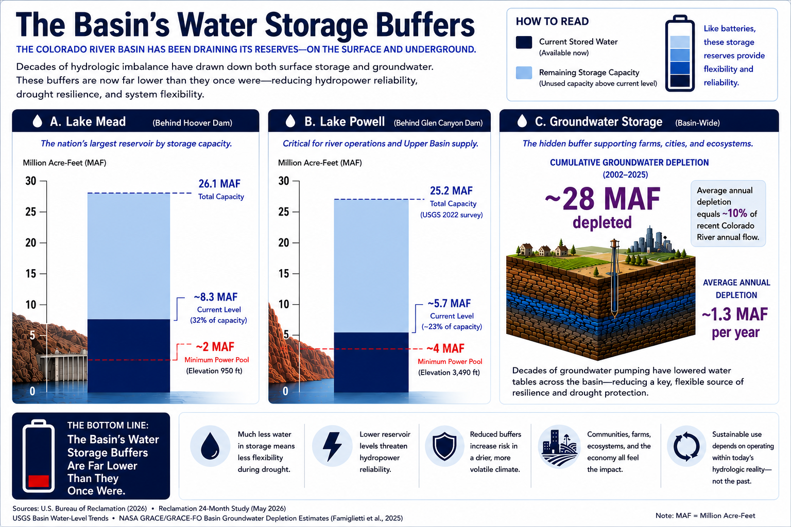
Caption: Reservoirs and aquifers act like giant “water batteries”, buffering hydrologic imbalance by storing water across both surface reservoirs and underground aquifers.
Spring 2026 conditions shown. Groundwater depletion estimates derived from NASA GRACE / GRACE-FO studies.
Climate Change Amplifies an Already Stressed System
Climate change is amplifying the Colorado River Basin’s structural imbalance. Higher temperatures increase evaporation from the ground and reservoirs and enhance transpiration from vegetation. Warming also reduces runoff efficiency, meaning a smaller fraction of precipitation ultimately becomes river flow because parched soil can soak-up snowmelt before it ever reaches the river.
The term “drought” implies eventual return to prior conditions and “aridification” implies the baseline itself has shifted. Research increasingly suggests the basin is experiencing long-term aridification rather than a temporary drought cycle, creating a more difficult operating environment for a system already managing imbalances between supply, storage, and demand.
At the same time, climate volatility itself is increasing, and is projected to only get worse as greenhouse gas levels increase. The basin now faces more extreme precipitation swings, longer dry periods, warmer temperatures, reduced and more variable snowpack, and more challenging forecasting. These effects increase uncertainty, which makes improving operational flexibility even more urgent.
Water Rights, Consumptive Use, and System Arithmetic
The Colorado River Basin is ultimately governed by hydrology: long-term consumptive use cannot continually exceed long-term available supply without progressively drawing down finite storage systems.
Historically, western water law created “use it or lose it” dynamics in many regions. Water-right holders were disincentivized from reducing long-term use because that could result in losing those water rights. In practice, it also created incentives to continue using water even when more efficient alternatives existed. Conservation only stabilizes a hydrologic system if conserved water actually results in increased river flow.
About 75% of the Colorado River's consumptive use goes to agriculture, reflecting more than a century of agricultural development built around earlier hydrologic assumptions, reservoir expansion, groundwater availability, and legal allocation frameworks developed during wetter periods.
Agriculture across the basin is highly diverse. Some farming systems generate enormous economic and food-system value relative to their water use. Others less so, and may become increasingly difficult to sustain under tighter hydrologic constraints.
Municipal consumptive use is also an opportunity. For example, outdoor irrigation remains a major component of urban water use and municipal drinking water distribution networks lose substantial amounts of water through aging infrastructure. Industrial demands - power plants, semiconductor fabs, manufacturing, and now data centers - represent newer consumptive uses the compact planners couldn’t anticipate.
The long-term solution for consumptive use reductions is unlikely to come from any single sector alone. Long-term stability will likely require coordinated improvements across agriculture, municipalities, industry, groundwater management, and basin-wide operations.
The Great Salt Lake Parallel
The Great Salt Lake and the Colorado River crises have similar underpinnings. Both systems were built on assumptions formed during wetter historical periods. Both have agriculture as the dominant consumptive sector - about 65% in the Bear/Weber/Jordan basins and roughly 75% in the Colorado Basin. Both run on a "use it or lose it" prior-appropriation framework that disincentivizes conservation. And in both, conservation only stabilizes the system if conserved water actually reaches the lake or the river. Efficiency gains that simply get re-diverted upstream deepen the imbalance rather than fixing it.
The Great Salt Lake reached crisis conditions earlier and the GSL basin is primarily within a single state, making ownership and management of changes easier. As the GSL’s levels collapsed, the consequences became impossible to ignore, including:
Loss of over half the lake’s surface area
Toxic lakebed dust that darkens skies and creates respiratory problems
Economic disruption
A shorter ski season
Growing pressure on state leadership to respond.
Those factors, and the region’s planned hosting of the 2034 Winter Olympics, have accelerated policy action in the past few years and especially so in the past ~9 months.
Many of the tools Utah is now deploying for the Great Salt Lake, including compensated agricultural leasing, "shepherding" conserved water through the system without water rights forfeiture, turf replacement programs, and return-flow protection, are the same tools that need to scale across the seven-state Colorado Basin. Utah is, in effect, a smaller and faster-moving testbed for the Colorado River.
2026 is a defining year for both. For the Great Salt Lake, this runoff cycle is a critical inflection point ahead of the 2034 Olympics. For the Colorado River, the post-2026 operating framework will be written this year - either negotiated by the seven states or imposed by the Bureau of Reclamation if they can't agree.
Colorado River Basin 2.0
The Colorado River Basin 1.0 was an extraordinary success under the hydrologic conditions and assumptions of its era, but the physical reality now is different. River flows are lower than originally assumed, hydrologic variability is increasing, reservoir storage levels are far lower than historical norms, groundwater depletion has accelerated significantly across many regions, and climate change is amplifying operational stress across the system.
As long as the reservoirs remained full enough, the system had flexibility to manage temporary imbalances, drought cycles, and hydrologic volatility. But lower storage levels fundamentally change the operating environment. The lower the water batteries become, the less flexibility the basin retains to absorb future shocks, protect hydropower generation, manage prolonged drought, or stabilize deliveries during highly variable years.
Tensions between the Upper Basin states (Colorado, Utah, Wyoming, and New Mexico) and the Lower Basin states (California, Arizona, and Nevada) have intensified as Lake Mead and Lake Powell, the basin’s primary operational storage buffers, have declined. The Lower Basin depends heavily on water stored within these reservoirs and increasingly fears bearing the brunt of future shortages if storage continues to decline, while Upper Basin states increasingly argue that the river itself no longer consistently produces enough water to support the assumptions underlying the original allocation framework.
The current rules governing how the basin operates, the 2007 Interim Guidelines and the 2019 Drought Contingency Plans that supplemented them, expire at the end of 2026. The seven basin states have been negotiating a successor framework, but Upper Basin and Lower Basin proposals submitted to Reclamation in 2024 remain far apart. If the states cannot reach agreement, the Bureau of Reclamation has signaled it will impose its own operating rules. Any federal solution is likely to be litigated for years. The window for a negotiated outcome is narrow.
The need for a new operating system is clear. Colorado River Basin 1.0 was designed based on assumptions of relatively stable long-term flows and periodically replenished storage systems. Colorado River Basin 2.0 requires accepting lower average flows and operating with substantially greater flexibility during prolonged droughts and more variable hydrologic conditions.
Why the Basin Can Adapt
But the future of the American West need not be fundamentally constrained or doomed. The basin possesses advantages that did not exist when the original system was constructed more than a century ago: extraordinary infrastructure, advanced engineering capabilities, sophisticated utilities, world-class research institutions, modern forecasting tools, advanced agriculture, deep capital markets, and a rapidly growing ecosystem of water innovators and technology providers.
Population growth continues across much of the American West. The region is also seeing increasing industrial activity tied to advanced manufacturing, semiconductors, data infrastructure, mining, electrification, energy systems, and domestic supply-chain expansion. These industries require water. Future economic growth increasingly depends on smarter water systems.
Water does not need to become a hard constraint on future economic growth in the American West. But maintaining long-term economic stability under tighter hydrologic conditions will require operating the basin in a fundamentally different way.
The Tools at Hand
The next phase of basin management will require better alignment between water use and long-term hydrologic conditions, such as a broad portfolio of coordinated adaptations across agriculture, municipalities, groundwater systems, infrastructure, industrial systems, reservoir operations, and water policy itself.
Agricultural activity will persist across the basin, but long-term consumptive use must decline under lower-flow conditions. Achieving those reductions will require policy reforms that mitigate the “use it or lose it” disincentives.
More efficient irrigation systems, optimized crop selection, compensated and rotational fallowing programs, and improved operational flexibility can all help reduce long-term consumptive use while preserving agricultural productivity.
Municipal and industrial systems are also opportunities for meaningful efficiency improvements and consumptive-use reductions. Smarter landscape irrigation, turf replacement programs, real estate efficiency, municipal water leak reduction, advanced reuse systems, and industrial efficiency & recycling can all help reduce long-term demand without fundamentally constraining economic growth.
Improved groundwater management also needs to be part of creating the next operating framework. Aquifers are a hydrologically connected part of the basin. Long-term basin stability will likely require slowing groundwater depletion, improving recharge where possible, and treating aquifers as strategic long-duration storage reserves rather than continuously declining backup systems.
Tribal participation in Basin 2.0 needs to be substantive, not procedural. That means quantifying the tribal water rights that remain unresolved, funding the infrastructure needed to actually deliver water tribes are legally owed, and including tribes in basin-level decision-making rather than informing them after the fact. There are some positive signs. The 2022 Colorado River Indian Tribes (CRIT) Water Resiliency Act gave CRIT, an Arizona-based tribe, authority to lease water off-reservation - an example of the shift from legal paternalism to respect for sovereign rights, and a working template for what tribal participation in Basin 2.0 can look like.
The reservoirs themselves need to be managed differently. Basin 1.0 evolved with the assumption that available water would eventually be allocated and consumed in full. Basin 2.0 requires intentionally rebuilding and maintaining larger operational storage reserves within Lakes Mead and Powell in order to restore resilience and improve the basin’s ability to overcome aridification and variability. Operating indefinitely near depletion negates the buffering effect these reservoirs were designed to provide.
New water-supply augmentation strategies can become part of the solution portfolio. Advanced water recycling, indirect and direct potable reuse, industrial recovery systems, and stormwater capture can all play a role. Also, large-scale seawater desalination supporting coastal California, if funded at least in part outside of California, could be a new virtual source of Basin water, potentially providing up to 1-2 MAF of the state’s Lower Basin allocation.
Cost, Governance, and Scale
The basin will require more flexible operational frameworks capable of adapting to variable hydrologic conditions rather than relying too heavily on fixed assumptions. A river system with plausible flow averages for the next century in the 9 to 13 MAF range, depending on the pace of aridification, cannot be sustainably managed the same way as a river system assumed to carry 16.4 MAF annually.
As storage buffers become increasingly ineffective and stress intensifies, the basin’s governance structure will become increasingly unstable. Because the federal government controls the basin’s major reservoir infrastructure through the Bureau of Reclamation, prolonged water stress will increasingly shift authority toward federal intervention if interstate negotiations fail to produce durable agreements.
None of this will be easy. Large systems don’t adapt quickly, especially when water rights, food systems, ecosystems, energy infrastructure, interstate politics, tribal rights, international treaties, and tens of millions of people are involved. But the necessary transformation could be economically manageable, and far less painful than the cost of inaction.
A back-of-the-envelope calculation: if long-term basin stabilization ultimately required reducing or offsetting consumptive use by ~4 MAF annually, and if the long-term cost of achieving those reductions averaged on the order of $250/AF to $500/AF (through some combination of conservation, compensated fallowing, reuse, infrastructure, desalination, operational changes, and other measures), the resulting costs could be on the order of ~$1-2 billion annually.
The Colorado River Basin supports roughly $1.5 trillion annually in economic activity and approximately 16 million jobs. Consequently, major long-term investments in efficiency, infrastructure, reuse systems, desalination, storage recovery, and operational flexibility should be economically rational - think of them as an affordable insurance premium of ~0.1%.
Conclusion
The Colorado River transformed the modern American Southwest and it’s the lifeblood for 40 million people and $1.5 trillion in economic activity. The rules governing it expire this year. It's time for an upgrade.
The challenge is enormous. But so was building the original system in the first place. Creating Colorado River Basin 2.0 that serves the West for the next century is a hard, but solvable problem. The deadline is short, the stakes are large, but the tools exist. What happens in 2026 will define the basin’s future.